Orod Elu
Orod Elu or Mount Elwe was a tall peak in the southern Blue Mountains.
Indication of localisation placement[]
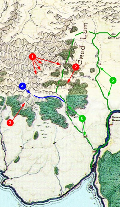
The location of this mountain is debatable because the MERP fan module (A Traveler's Guide to Lindon) provides two contradictory placement tips. Locations are marked respectively on the image below.
Location [pin 1, pin 2][]
THE ABANDONMENT OF LINDON AND ITS EFFECTS: "Elven villas in the area have been fallen into ruin as the Sindar and Nandor of that area avoid these intruding mortals [into Harlidnon - red.]. None the less, Cirdan himself has refused to allow the local nobles to drive off the newcomers. Instead he has demarked a new boundary along the stream which flows from Orod Elu south to the inlet of the Baranduin."
MERP map provides only one such river that flows from between a mountain(s) and ending directly into inlet of Baranduin (at "the elder and larger river-port" than Annon Baran) but at the this river source there's lack of significant mountain [pin 2], it's unlikely that Orod Elu would be minor mountain or just a hill top ending range of hills stretching out from the main mountains range.
However, from the another passage we have learned that border river between Harlindon and Siragale is river Ilinló with it's principal tributary Luithen - treating this tributary river as the described stream we got access to a location of high mountain mapped on MERP map [pin 1] - quite southern but not southernmost. > but within this statement we came up to historically incorrectness: Cirdan wouldn't place new border caused by abandoment of lands east from mountains, that up to mid-Third Age were allready abandomend by the Elves (e.g. Annon Baran).
Location [pin 3][]
ERED LUIN: "The southern-most peak is Orod Elu in Harlindon (6,824 feet)."
Taking literally "The southern-most" as a main fact, that would be position marked [pin 3] but it's not possible that any water flow would goes from this mountain, across and against topography mapped on MERP map and allready marked rivers, to Barandiun.
From the other hand, mentioned stream: "flows south to the inlet of the Baranduin" and NOT "flows south of the inlet of the Baranduin"
Conclusion [pin 4]:[]

Suggested localistaions of Orod Elu
To satisfy both location tips left in A Traveler's Guide to Lindon, we must assume that the described in text stream (marked by a blue line) has not been mapped on the MERP map.
The stream has a source at the northern mountain slopes (it would be Orod Elu [pin 4]), goes downstream to meet with inlet to [unnmaed river] but in this case this stream itself would be the mine river - proposed river name: Elweithen.
With location marked by [pin 4] we got southern but not southern-most peak - which is correct/convergent comapring to geograpihcal and historical background of hints left in A Traveler's Guide to Lindon - mainly historical background of section: THE ABANDONMENT OF LINDON AND ITS EFFECTS
For better understending I'm also marking borders of Lindon during the time:
[pin 5] green solid line: initial Lindon border during SA, since mid-SA elvish community is dicreasing significally est of green dashed border line.
[pin 6] green dashed line: new Lindon border demarked Lindon borders for mid-TA ("The Pinnath Luin are Elf-lands until the late Third Age").
References[]
- Jeff J. Erwin: A Traveler's Guide to Lindon
