While certainly an important source these maps are also often considered just rough drafts, early processing steps which just represent very early concepts Professor Tokien never again revisited and never officially released in his lifetime. While many later interpreters tried to keep as close as possible to these Sketches, others argued that Tolkien certainly would have reworked and revisited his earliest Sketches and would have altered them to avoid a too strong resemblance to modern maps of our Earth's Landmasses.On the other hand, the close resemblance of the Professor's Shaping of Middle-Earth Maps to early illustrations of Plate tectonics have inspired several Artists to elaborate the similarities between Ambar and Pangea or Middle-Earth/Southernesse and Laurasia/Gondwanaland.
While certainly an important source these maps are also often considered just rough drafts, early processing steps which just represent very early concepts Professor Tokien never again revisited and never officially released in his lifetime. While many later interpreters tried to keep as close as possible to these Sketches, others argued that Tolkien certainly would have reworked and revisited his earliest Sketches and would have altered them to avoid a too strong resemblance to modern maps of our Earth's Landmasses.On the other hand, the close resemblance of the Professor's Shaping of Middle-Earth Maps to early illustrations of Plate tectonics have inspired several Artists to elaborate the similarities between Ambar and Pangea or Middle-Earth/Southernesse and Laurasia/Gondwanaland.
+
+
Karen Wynn Fonstad's ''The Atlas of Middle-Earth'' stayed very close to Professor Tokien's early Ambarkanta Sketches, but added the Lord of the Rings maps as a link between the Beleriand map and the continental sketches. ''An Artist's Interpretation of Middle Earth, including the wild lands east,south and north'' by [[Pete Fenlon]] went the other way and, while still loosely based of Tolkien's Ambarkanta Sketches, tried to alter the continent's Shape in the attempt to create a continent that bore as little resemblence to Africa or Asia as the Westlands did to europe (while Pete Fenlon still included some allusions to real-world geographical features).
==References==
==References==
Revision as of 23:57, 23 April 2016
The Shaping of Ambar through the Ages
Middle-Earth, also known as Endor (S.Middle-Land) was the largest continent on Ambar (the World) in Arda (the Realm of Manwë). It´s inhabitants were the children of Eru, the Elves, Hildor (or mortals, including men and Halflings), Dwarves and Ents as well as the Melkorindi or Uvanimar, the Orcs, Trolls and Dragons. Middle-Earth was also known to be the Home of a number of lesser Ainur or Maiar and enigmatic peoples as the Giants and a countless number of Olvar and Kelvar or Plants and Animals.
The best known part of Arda were the Westlands, roughly the northwestern part of the continent with the icy Forodwaith in the north, the hot Haradwaith in the south, the Sea of Rhûn in the east and the great ocean Belegaer in the west.It comprised the Lands of Lindon, Eriador (Including the lost Kingdom of Arnor and its successor realms as well as Enedwaith), Rohan (or Calenardhon), the Lands of Rhovanion, the southern Kingdom of Gondor and the dark land of Mordor.
The Lands of Rhûn and Haradwaith were known quite well in the southern kingdom of Gondor since they once were provinces of it´s dominion, the Lands further to the east and south were known as the Wild Lands east and South, Tribal areas often under the sway of the dark Lord or inhabited by wild rebellious tribes loyal to none but themselves.The Númenóreans had built many colonies in the south along the western coast, many of which later became the homelands of the so-called black númenóreans.
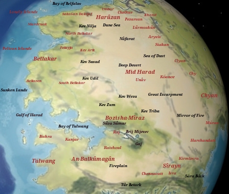
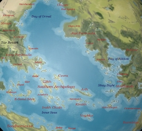
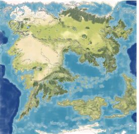
Middle-Earth Map by Haerangil, a try to reinterpret Pete Fenlon's Interpretation of Middle-Earth to a larger scaled map, working with analogies between his map and real-world Asia and Africa
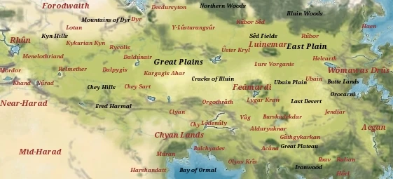
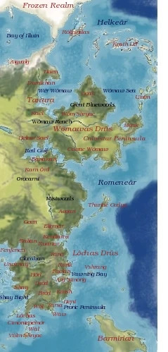
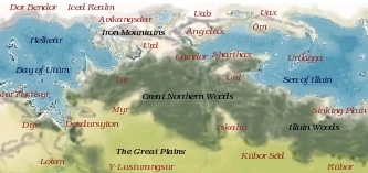
Middle-Earth Map by Thomas Morwinsky, combining Pete Fenlon's Interpretation of Middle-Earth with Elements from the Hârnworld Map
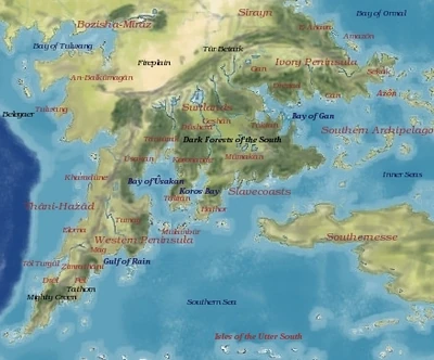
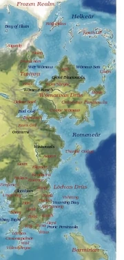
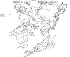
Middle-Earth Map by Thomas Morwinsky, combining Elements from J.R.R. Tokkien's Sketches with Elements of Pete Fenlon's Middle-Earth Map
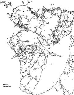
What dit Middle-Earth actually look like outside the Westlands? While Professor Tolkien gave us quite a good set of Maps to imagine what he had in mind for the Westlands and Beleriand in the First and late Third Ages he only gave vague hints to the geography of the entire continent. His writings offer us some hints, the Orocarni are mentioned as a great mountain chain in the farthest east, he mentions wild woods in the east (around the Bay of Cuivienen), great pinewoods to the North (north of Helcar and Cuivienen) and the great forests of the south (south of Umbar of Far Harad), the Great Inland Seas of Helcar and Ormal,vast Grass plains in Palisor, implied to stretch between Cuivienen and the later Inland sea of Rhûn, the Lake of Almaren in the center of the World, A mountain chain known as the Mountains of the Wind near the center of the world, near to the Murmenalda in the Land of Hildorien (once implied to correspond with mesopotamia) and another unnamed mountain chain implied to have been situated half way between the Orocarni and the Iron Hills, the great Iron Mountains and old Utumno in the far North, deserts and wooded coastal lands and former Black Númenórean Colonies along the Coasts of Harad and several island chains in the Belegaer.However aside from brief mentioning these geographic features we don't get map material to illustrate them or give us a better idea about Ambar outside the Northwest.Except for a few rough Sketches and Drawings.
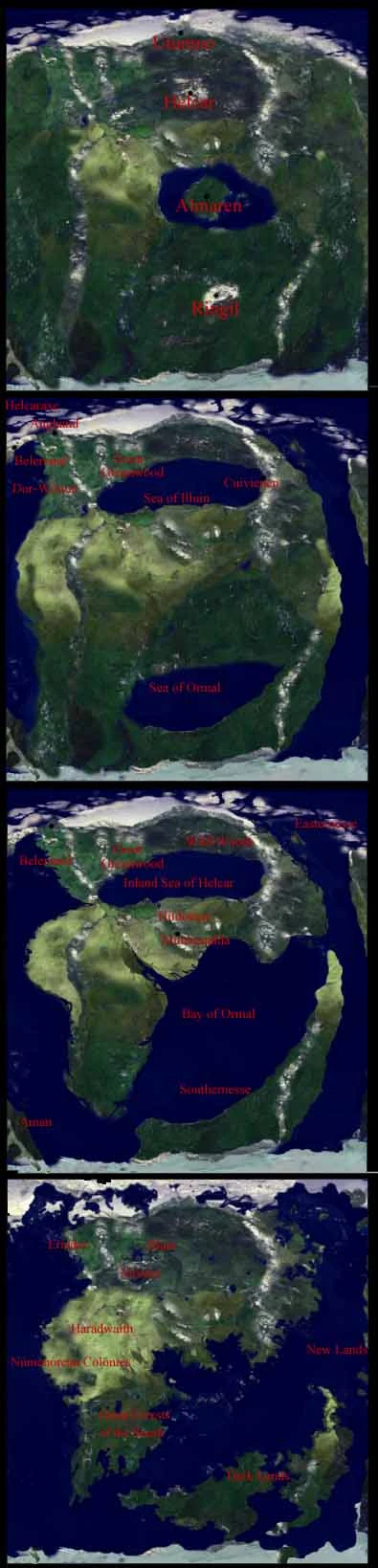
Best known are his raw sketches published in The Shaping of Middle-Earth which give us a clue how he imagined the entire continent (and indeed also Aman, Southernesse and Easternesse, Ambars other three major landmasses) to look like. He drew a very quick Sketch of Beleriand as the northwesternmost tip of a somewhat larger continent which strongly resembled Africa to the south, the Arabian peninsula at the centre, India or Thailand/Myanmar/Cambodia/Viatnam in the southeast and China in the far east. Also his Sketch gives us hints about the Great Mountain chains (Hithaeglir, Ered Engrin, Orocarni, Mountains of the Wind) and mentions two more :the Yellow Mountains and the Grey Mountains , gives us a better idea of the inland sea of Helcar and the Bay of Ormal, Hildorien, Cuivienen, Almaren and the continent known as the Dark Lands or Southernesse, often compared by commentators to Australia, Antarctica, Oceania and Indonesia, as well as Easternesse and Aman, which were sometimes compared to the Americas, Lemuria and Mu.
Two more less known and less frequently hints may be Tolkiens early drawing of the "World Ship" and the World of Arda, published in the Book of Lost Tales and a painting by Professor Tolkien , entitled The Man in the Moon, showing the Moon with it's Towers, and faraway, Planet Earth, with the continents Northamerica, Eurasia, Africa and possibly Atlantis nad Mu or Lemuria.
While certainly an important source these maps are also often considered just rough drafts, early processing steps which just represent very early concepts Professor Tokien never again revisited and never officially released in his lifetime. While many later interpreters tried to keep as close as possible to these Sketches, others argued that Tolkien certainly would have reworked and revisited his earliest Sketches and would have altered them to avoid a too strong resemblance to modern maps of our Earth's Landmasses.On the other hand, the close resemblance of the Professor's Shaping of Middle-Earth Maps to early illustrations of Plate tectonics have inspired several Artists to elaborate the similarities between Ambar and Pangea or Middle-Earth/Southernesse and Laurasia/Gondwanaland.
Karen Wynn Fonstad's The Atlas of Middle-Earth stayed very close to Professor Tokien's early Ambarkanta Sketches, but added the Lord of the Rings maps as a link between the Beleriand map and the continental sketches. An Artist's Interpretation of Middle Earth, including the wild lands east,south and north by Pete Fenlon went the other way and, while still loosely based of Tolkien's Ambarkanta Sketches, tried to alter the continent's Shape in the attempt to create a continent that bore as little resemblence to Africa or Asia as the Westlands did to europe (while Pete Fenlon still included some allusions to real-world geographical features).
References
Lords of Middle-Earth II:the Mannish Races
Middle-Earth Campaign Guide I
The Wild Lands South and East, Gazetteer by Pete Fenlon


